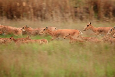
The University of Wyoming’s Matt Kauffman, Shannon Albeke and William Kirkpatrick were among 80 worldwide scientists who contributed to a United Nations’ living atlas that recently launched and shows the live migrations of ungulates, including antelope, guanacos, and zebras, as well as many other land-hoofed animals around the globe.

Called the Atlas of Ungulate Migration, the interactive migration map was created by the Global Initiative on Ungulate Migration (GIUM) working in partnership with the Convention on the Conservation of Migratory Species of Wild Animals (CMS)—an environmental treaty of the United Nations. Eight international scientists, including Kauffman, created the new atlas, which launched Sept. 4.
“This atlas represents a major milestone for conservation worldwide, and we believe the migration maps will be a tangible and effective tool to help stem the loss of the world’s ungulate migrations,” says Kauffman, a wildlife biologist with the U.S. Geological Survey (USGS). He also is a unit leader of the Wyoming Cooperative Fish and Wildlife Research Unit at UW and a member of GIUM’s Scientific Advisory Board.
The longest mule deer migration on record—a 300-mile round-trip journey that stretches from the greater Yellowstone ecosystem in the northwest corner of Wyoming to southern Wyoming’s Red Desert and was a long-term USGS study led by Kauffman—is among 20 global mammal populations that are part of the atlas. Other mammals include the African elephant, Cape buffalo, Mongolian gazelle, Saiga antelope, and the Serengeti wildebeest.
“In the American West, it has taken close collaboration with many partners to map ungulate migration routes, and it’s been exciting to team up with this global community of researchers,” says Kauffman, who helped lead the international team. “In this new international effort, we’ve expanded the scientific approach to understanding migrations by leveraging existing workflows we developed for sharing data, analyzing migration tracks, and making the resulting migration maps publicly available.”
UW’s Wyoming Geographic Information Science Center (WyGISC) also played a key role in developing the back-end database and computing architecture that allow users to seamlessly access the new migration maps via a powerful web mapping application.
“WyGISC contributed resources to launch the interactive online map and is hosting all of the data and application programming interfaces,” says Albeke, a senior research scientist in WyGISC. “The map, which also can be viewed online by the general public, will be used to inform conservation decisions, government policies, and infrastructure development as the various species of ungulates migrate large distances throughout the year.”
Essentially, WyGISC provided the cyberinfrastructure and tools necessary to upload new data to the web application. Albeke and Kirkpatrick, a geospatial technician in WyGISC, built a data pipeline using a software program—known as Program R—to assist ungulate biologists in the uploading of new migrations to the central database using a web application programming interface (API).
Steffen Mumme, GIUM’s lead spatial analyst, was the main data processor for the migration map. He processes ungulate GPS collar data using Program R and then uses WyGISC’s data pipeline tool to add migration information to the database, Albeke explains.
The web API then allows for on-demand queries of the available data and provides map vector tiles as a map service to Josh Gage, the web application developer, who is located in Montana. The InfoGraphics Lab at the University of Oregon helped build most of the graphics and visualizations that are part of the web application, “so this truly is a global endeavor,” Albeke says.
The Atlas of Ungulate Migration is expected to be used by conservationists and governments around the globe.
“Knowing the routes used by these animals for their migration is essential to better understanding what we must do for their conservation and management,” says Amy Fraenkel, CMS executive secretary, in a statement. “The atlas will be a significant tool for policymakers to achieve their biodiversity objectives, as well as addressing the needs of communities for development.”
“These maps also can serve as a baseline for what exists,” Kauffman says. “Without such maps, it’s often hard for us to visualize how much we’re losing.”
To view the Atlas of Ungulate Migration, go to www.cms.int/en/gium/migration-atlas.
This story was originally published on UW News.


