
October 1 marked the start of the new water year and, as always, there’s been a lot of coffee shop conversation regarding the upcoming winter season. What is expected for precipitation and where will it fall? What about daily high and low temperatures and passing storm fronts?
For the farmers and ranchers who depend on the weather to make their living, these things matter. Local weather conditions—especially precipitation—can mean the difference between profit and loss. Having access to reliable and accurate weather information is critical to agriculturalists in Wyoming.
For those looking for high-quality forecast information, the WY Conditions & Outlooks monthly webinar series provides reliable predictions on upcoming weather trends. Likewise, high-quality weather and conditions data are collected daily through the Community Collaborative Rain, Hail and Snow Network, making forecasting information more robust for everyone.
WY Conditions & Outlooks monthly webinar
While short-term forecasts looking to the next 24 or 48 hours are helpful for daily updates, many planning tasks on the farm and ranch need a larger scope.
Did you know there is a monthly update, hosted by a team that lives and works in Wyoming, that provides long-term weather conditions and outlooks?
The University of Wyoming Extension partners with the National Weather Service’s Riverton and Cheyenne offices, the Wyoming State Climate Office, Wyoming Water Resources Data System, the Wyoming State Engineer’s Office, the USDA, the U.S. Geological Survey, the Bureau of Reclamation, and others to host the monthly WY Conditions & Outlooks webinar.
Webinars are held regularly on the third Thursday of the month at 1:00pm MST. To be added to the email list and receive an invitation to register, please contact UW Extension educator Callie Surber at csurber@uwyo.edu.
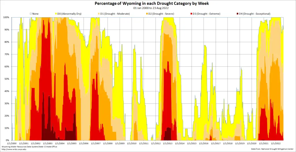
In each webinar, guest speakers outline current conditions throughout Wyoming, including departures from average temperatures, precipitation, and stream flows in the previous month. These factors all contribute to the U.S. Drought Monitor status, so attendees gain a better understanding of how conditions are shaping this important tool.
Then, staff from National Weather Service (NWS) offices in Wyoming provide a near-term weather forecast. The Riverton and Cheyenne offices both contribute, depending on availability from month to month.
Which NWS office covers forecasting for your county?
- Cheyenne, Wyoming: Albany, Carbon, Converse, Goshen, Laramie, Niobrara, Platte: Cheyenne, Wyoming
- Rapid City, South Dakota: Campbell, Crook, Weston
- Riverton, Wyoming: Big Horn, Fremont, Hot Springs, Johnson, Lincoln, Natrona, Park, Sweetwater, Sublette, Teton, Washakie
- Billings, Montana: Sheridan
- Salt Lake City, Utah: Uinta

Each webinar concludes with a highlight of the month, which typically focuses on a water- or weather-related topic relevant to Wyoming. Past highlights have included Grass-Cast from USDA Climate Hub, the Vegetation Drought Response Index (VegDRI) tool, the Western Water Assessment Dashboard, and the Wyoming-Montana Drought Viewer from the U.S. Geological Survey.
These tools provide data to aid in decision-making, especially for building grazing plans and determining water availability for irrigation.
Recordings of WY Conditions & Outlooks webinars can be viewed on the University of Wyoming Extension YouTube channel at https://bit.ly/WY-conditions-25 or at https://drought.wyo.gov.
Community Collaborative Rain, Hail and Snow Network
A common piece of feedback received from webinar attendees is that the Drought Monitor and/or conditions maps do not match on-the-ground conditions for a particular location. These tools are created using the best data available, but there are gaps around the state where data are difficult to capture or access. Community volunteers can help fill these gaps.
The Community Collaborative Rain, Hail, and Snow Network (CoCoRaHS) is a community science project that captures real time, on-the-ground precipitation and conditions data. These data directly inform the U.S. Drought Monitor and drought condition status for a specific location.
The CoCoRaHS Network depends on a group of volunteers who observe and report daily precipitation where they live. Individual data points are pieced together to more accurately describe individual weather events and general trends in precipitation. A lot of variation occurs in a single storm—as you’ve probably noticed, rainfall totals are another popular coffee shop conversation topic.
There are also options within the CoCoRaHS system to report local conditions, evapotranspiration, and soil moisture levels for folks who want to engage at that level. This is a way to contribute observations of how local weather is impacting rangelands, forage, garden crops, wildlife habitat, and outdoor recreation in Wyoming communities.
Joining the CoCoRaHS Network is simple: create a free online account and acquire a four-inch standard rain gauge. The author can assist with any of these steps as needed. The CoCoRaHS team has created excellent training videos that go over best practices for making observations. Watch the short training videos here: https://bit.ly/CoCoRaHS-training.
Most farmers and ranchers already closely monitor precipitation and conditions on their operations—using CoCoRaHS is a way to communicate that information to experts who use it to develop better forecasts, which in turn help farmers and ranchers make decisions on their operations.
Wyoming weather is notorious for being unpredictable and extreme. Join the next WY Conditions & Outlooks webinar or consider joining the CoCoRaHS Network to ensure you have the inside scoop for your next coffee shop conversation.
Micah Most is an agriculture and natural resources educator with University of Wyoming Extension serving Johnson County and northeast Wyoming. He can be reached at mmost@uwyo.edu.