After Hurricane Milton decimated many parts of Florida in early October, Ramesh Sivanpillai received a familiar call.
No stranger to assisting with natural disasters, Sivanpillai, a University of Wyoming instructional professor in the School of Computing and Wyoming Geographic Information Science Center (WyGISC), was tapped by the International Charter Space and Major Disasters to help with mapping damaged homes, buildings, and other infrastructure in Florida caused by Milton.
The International Charter Space and Major Disasters, formed in 1999 by the United Nations, consists of members from 17 charter countries and has responded to disasters in 136 countries, providing free satellite data from 270 contributing satellites for the impacted regions. To date, there have been 933 activations.

Sivanpillai was called to serve as a value-added data provider (VAP) by Brent Yantis, Regional Application Center director at the University of Louisiana at Lafayette, who is serving as project manager. VAPs process raw satellite and other data and generate value-added products.
“Working with the project manager, I identified the priority areas for identifying damaged structures and accident sites from satellite and aerial images acquired before and after the hurricane,” Sivanpillai explains. “Since Florida and other areas on the East Coast were hit hard by Hurricane Helene (Sept. 27), agencies needed any additional help they could get. The maps we generated will be used during field visits by federal and state emergency manage agencies.”
Milton hit Florida’s Gulf Coast Oct. 5 as a Category 3 hurricane. As the powerful storm made its way across the state, the hurricane caused record-setting storm surge, spawned numerous tornadoes, and unleashed heavy rains that resulted in extreme flooding.
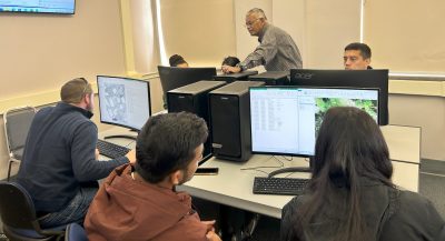
To help with the work, Sivanpillai recruited 32 UW students and five UW faculty/staff members who have identified more than 3,470 damaged structures in five Florida communities—Anna Maria Island, Fort Myers, Manasota City and adjacent areas, Manasota Key, and Siesta Key—during five separate disaster mapping sessions that began Oct. 10. To date, students have contributed more than 250 hours of disaster mapping work, he says.
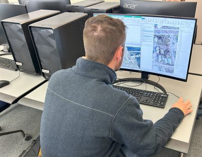
Before the disaster mapping sessions, three lead student volunteers downloaded the post-disaster images from the U.S. Geologic Survey website. During the sessions, volunteers viewed them in ArcGIS, a geospatial data analysis software. The software allowed students to obtain the geographic location of each home, building, marina dock, accident site, and flooded area. These locations were transferred to the damage assessment maps.
“In this software, everyone displayed the pre-damage images that showed the conditions in these locations before Hurricane Milton, and possibly Hurricane Helene, passed through,” Sivanpillai says. “Volunteers compared both pre-damage and post-damage images and labeled damages and accidents to one of 16 categories.”
Much of the damage found to residential properties and other building structures, including mobile homes, condominiums, and businesses, was in the form of roof damage, missing roofs, and other structural damage. Several structures and debris material were physically moved to new locations due to the force of the hurricane. For example, volunteers identified numerous locations where debris was strewn across backyards and in roads.
“Since these images show the vertical perspective or a birds-eye view, it was not possible to determine if the side walls were damaged or gave way,” Sivanpillai says. “We also identified numerous sites with damages to docks and piers that were partially damaged or missing, and debris strewn across backyards.”
To date, Sivanpillai and his team have identified 3,476 points of damage, with several points that correspond to multiple damage sites. For example, if a cluster of buildings was damaged in a similar way, such as having a missing roof, volunteers placed only 1 point and mentioned in the comments column that there were multiple, similar damages.

The point totals include parts of South Venice through Englewood, 1,051 points; Siesta Key, 816 points; Manasota City and adjacent areas, 696 points; Anna Maria Island, 555 points; and Manasota Key, 358 points. The team has yet to finalize another 300 points of damage in Fort Myers and neighboring locations.
The extent and severity of damage was eye-opening, Sivanpillai says.
“In addition to flooding, several tornadoes touched down or high gusts went through these areas. It was extremely sad to see that people living in those areas have lost so much, and some lost almost everything they had in these areas,” he says. “At the same time, we found several sections with no damages that could be identified from these photos.”
Sivanpillai was pleasantly surprised at the number of students and a few staff members who came to the five mapping sessions.
“Their contributions were invaluable,” Sivanpillai says. “Without their contributions, we could not have made such progress. After two sessions, several volunteers asked me about the next session. Students who initially said they had only 45 minutes to spare were working after two hours or so.”
He adds, “It was gratifying to see that several domestic and international students from UW volunteered for this project, whether they had a relative or friend or knew someone in Florida.”
Participating UW students, listed by their hometowns and majors, are:
- Ackley, Iowa—Taryn Day, zoology.
- Cheyenne—Kaeden Adams, geospatial information science and technology; Ellie Birge, geography; Morgan Bugg, geospatial information science and technology; Andrea Edwards, history; Anna Erdmann, international studies; and Kristen Huffman, management.
- Elgin, Ill.—Robert Anderson, wildlife and fish biology and management.
- Hartland, Wis.—Sophia Nowak, wildlife and fish biology and management.
- Jakarta Bar, Indonesia—Friets Menanti, energy resource development/management; Aris Wanimbo, environmental systems science; and Jaineth Youwe, energy resource development/management.
- Koforidua, Ghana—Ivy Kwashie, geospatial information science and technology (master’s).
- Lagos, Nigeria—Francis Okwuzu, environmental engineering (master’s).
- Lander—Shayla Babits, environmental and natural resources.
- Laramie—Samantha Bemis, biology; Martin Buchanan, religious studies; Jeremy Chappell, environmental systems science; Annalee Galley, outdoor recreation and tourism management; Madaline Huffman, marketing; Colb Stickelman, environmental systems science; Korrin Sutherburg, geospatial information science and technology; Andi Swedborg, environmental systems science; Natalie Williams-Todd, undeclared major (master’s); and Sage Wright, geospatial information science and technology.
- Loveland, Colo.—Devon Borthwick, geospatial information science and technology (master’s).
- Mexico City, Mexico—Samuel Gonzalez Garcia, computer science.
- Montrose, Colo.—Reina Galvan, zoology and physiology (master’s).
- Panama City, Fla.—Jackson Alford, rangeland ecology and watershed management (master’s).
- Ramarosha, Nepal—Purna Saud, geospatial information science and technology (master’s).
- Rock Springs—Kyle Ridenour, environmental systems science.
- Sheridan—Emma Oettken, environmental systems science.
In 2011, Sivanpillai was tapped by the charter to assist with major flooding along the Mississippi River that started in Illinois, an event that lasted roughly five months. Two years before that, Sivanpillai was selected by the U.S. Geological Survey for project manager training in Denver. While a student at Texas A&M University in 1999, he volunteered to help with relief efforts in Nicaragua.
In 2018, Sivanpillai was again called by the charter to serve as a project manager for the Camp Fire that engulfed the town of Paradise, a community located in northern California. And, in fall 2022, Sivanpillai was tapped to be a project manager in response to Hurricane Fiona in the Dominican Republic.
Federal and state management agencies will use the maps generated by UW and other volunteers to conduct field visits and assessments. After these assessments, the agencies will estimate the hurricane damage in dollar amounts, Sivanpillai says. The International Charter is not involved in determining the monetary value of the damages, he adds.
The disaster mapping work at UW will conclude Sunday, Dec. 15, Sivanpillai says.
For more information about the charter activation for Hurricane Milton, go here.
This story was originally published on UW News.


