


The short days, long nights, and cold temperatures this time of year can be difficult for folks who enjoy keeping an eye on hay fields, pastures, lawns, and gardens during the warmer months.
It can feel like our winter interactions with the natural resources in our environment are limited to scooping snow out of the driveway and keeping livestock fed. Winter in Wyoming can be isolating. It can also be the perfect time to build a new habit and reconnect with nature and with others while making a difference in your community.
Enter the Community Collaborative Rain, Hail and Snow Network, fondly known by the acronym CoCoRaHS (say it with me, KOH-koh-rahz). This network of independent citizen-scientists report daily precipitation totals to supplement data collected by the National Weather Service. Active reporting takes place in all 50 of the United States of America plus Puerto Rico, the U.S. Virgin Islands, Guam, Canada, and the Bahamas. Wyoming has been a participating state since 2003.
All are welcome and encouraged to participate
Reporting for CoCoRaHS does not require any formal education or prior experience. Brief training modules, including an intro video, are available on the CoCoRaHS website and on YouTube. Participation in a comprehensive, hour-long introductory training session is strongly encouraged when initiating a new reporting site.
This activity is well-suited to people of all ages and walks of life. For schoolchildren, CoCoRaHS reporting can be good practice making observations and engaging with the natural world. It provides an enrichment opportunity for those living in retirement and senior communities. Many agricultural producers are already tracking their local rain and snow events, and CoCoRaHS is an easy way to digitize and archive measurements for later reference.
How it works
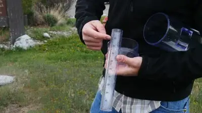
The necessary supplies are simple: a 4″ standardized rain gauge, a clear place to mount it away from obstructions, a free CoCoRaHS online account, and a decent internet connection. At a consistent time each day an observer reads their rain gauge, enters their measurement into their daily report using their CoCoRaHS account online or via the CoCoRaHS smartphone app, and then empties any collected moisture from the gauge so it is ready for the next 24-hour period. Note that zero values are just as important, if not more, to report as measured precipitation. If you have experienced three months with no precipitation, CoCoRaHS followers want to know!
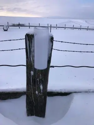
It gets a little more complicated when there is snow involved, but the fundamental process remains the same. Since snow varies in water content, it takes a few extra steps to measure the actual amount of water in a given volume of snow. The CoCoRaHS team has created several resources, including the following video, to help make the process easy: https://youtu.be/3yNj1xCjqB4.
There is also an option to enter a multi-day report for instances when you are unavailable for a few days. This has worked well for me since the gauge I report for is located at the Johnson County Extension office in Buffalo and I don’t tend to check it over the weekends. When I travel during the week, I use a multi-day report when I return to make sure that no days go unaccounted.
Why it matters
The CoCoRaHS program was created in response to a flooding event along the front range of Colorado that was not anticipated by the weather service. Rain fell heavily in some places but not at the location of the official weather station in Fort Collins, so officials were not aware of the threat of flooding. This incident raised awareness of how highly variable precipitation can be, even among locations less than half a mile apart. CoCoRaHS reporting helps fine-tune the understanding of storm profile—and the more reports submitted, the clearer the picture becomes. Participating allows you to keep a record of your local conditions and also benefits the community at large!
State meteorologists use CoCoRaHS data to anticipate severe weather events, as the network was originally intended. CoCoRaHS data is also used by climatologists to develop the Wyoming drought monitor map, and to track the snowpack that provides irrigation and drinking water to much of the Intermountain West. These data inform decisions made by state and local governments, which have direct impacts on those who depend on water for their livelihoods. (Think agriculturalists, outfitters, and all the businesses that benefit from regional tourism to lakes, ponds, reservoirs, rivers, and streams.)
How to get started
- Collect the required supplies. Visit the CoCoRaHS online store to view your options.
- Mount your official CoCoRaHS gauge in a site away from obstructions like houses and trees.
- Register your new reporting site at https://cocorahs.org/application.aspx. Connect with Wyoming CoCoRaHS Coordinator Tony Bergantino at antonius@uwyo.edu or (307) 766-3786 with questions or to sign up for a training session.
- Begin reporting daily precipitation totals, knowing that you are making a difference!
Summary
The Community Collaborative Rain, Hail, and Snow Network is a grassroots effort by citizen scientists to measure precipitation and improve weather and climate scientists’ ability to anticipate severe weather. The water data collected informs governmental policy at several levels, which has a direct impact on agriculture and other industries that depend on this critical natural resource. Participating in CoCoRaHS reporting is a simple to way to become more mindful of your local weather, connect with your natural environment, and benefit your community.
CoCoRaHS Resources & Training Materials
- CoCoRaHS Home Page: cocorahs.org
- CoCoRaHS Fact Sheet, UW Extension (includes video links)
- Collecting Precipitation Data Provides Information for Public Good, Barnyards & Backyards magazine
- Video: Are You Cuckoo for CoCoRaHS?
- Video: Getting Started with CoCoRaHS: The Basics of Reporting Rain
- Video: Setting up for Measuring Snow
Micah Most is a UW Extension agriculture and natural resources educator based in Johnson County. He can be reached at mmost@uwyo.edu.